


Notes from an Environmentalist; Beryl sets record as earliest Cat-5 hurricane in history.

Hurricane Beryl The Earliest Atlantic Category 5 On Record
By weather.com meteorologists
less than an hour ago
0 seconds of 0 secondsVolume 90%
00:38
00:52
At a Glance
Hurricane Beryl became the earliest Atlantic Category 5 overnight after hammering the Windard Islands Monday.
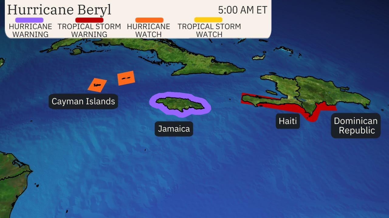
It's a threat to Jamaica, the Cayman Islands and Mexico's Yucatan Peninsula this week.
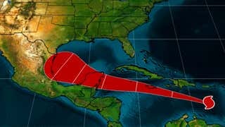
It's still too soon to tell where it will track in the southwest Gulf of Mexico this weekend.
Sign up for the Morning Brief email newsletter to get weekday updates from The Weather Channel and our meteorologists.
Hurricane Beryl became the earliest Atlantic Category 5 on record overnight following a historic Windward Islands landfall earlier Monday. It's not done yet, with Beryl likely to spread its impacts across Jamaica, the Cayman Islands and the Yucatan Peninsula before facing an uncertain future in the Gulf of Mexico.
Current status: Beryl remains a Category 5 with maximum sustained winds of 165 mph over the eastern Caribbean Sea this morning and is moving west-northwest.
Beryl is the earliest hurricane to reach Category 5 strength on record in the Atlantic, and it beat the previous record by more than two weeks. The previous earliest Category 5 was Hurricane Emily on July 16 during the hyperactive 2005 Atlantic hurricane season. Record warm water temperaturehave likely catapulted Beryl's intensity.

Here's where warnings and watches are in effect: A hurricane warning has been issued for Jamaica and a hurricane watch is now in effect for the Cayman Islands. Additional alerts could be issued later Tuesday or Wednesday.

Here's what to expect next from Beryl across the Caribbean: We expect Beryl to take a general west-northwest track in the Caribbean Sea through the rest of this week. Although the hurricane will steadily weaken because of increasingly hostile upper-level winds, it will still pose a considerable danger.
First, Beryl's outer impacts, including bands of rain, some storm surge flooding and tropical storm force winds could brush southern Hispaniola Tuesday into early Wednesday.
It poses the danger of storm surge flooding, damaging winds and rainfall flooding in Jamaica Wednesday. The Cayman Islands will also see those impacts from Beryl by Thursday.
(MORE: What The Forecast Cone Means, And Doesn't)
Beryl is still expected to be a hurricane until its landfall in the Yucatan Peninsula or Belize around Friday. These areas should prepare for strong winds, storm surge flooding and flooding rainfall.

Any U.S. concern? Beryl is likely to emerge in the southwest Gulf of Mexico this weekend after being steered by the western periphery of an upper-level high-pressure system over the Southeast U.S.
Although that high will weaken and shift east, some model tracks suggest its influence will remain strong enough to steer Beryl into eastern Mexico by early next week. However, it's also possible that Beryl could take more of a northward jog toward the Texas coast early next week if that high is weakened enough by an approaching cold front and its associated southward plunge of the jet stream.
Advertisement
Residents along the Gulf Coast from eastern Mexico to Texas should, for now, monitor the forecasts in the coming days.
Either way, Beryl should lose considerable strength by the time it reaches the southwest Gulf because of wind shear and land interaction, however it could still bring significant impacts.

Recapping Beryl's Historic Windward Islands Landfall
Beryl made landfall just after 11 a.m. EDT Monday over the Grenadan island of Carriacou with maximum sustained winds of 150 mph. Among only two other Category 4 hurricanes in history near Grenada and St. Vincent and the Grenadines, Beryl was the strongest by wind speed.